Gallery of Addresses
What's in the gallery?
Contained in this gallery are images of roads, streets and thoroughfares within the area defined as Sprowston in its widest sense. This is necessary as in 1907 the City of Norwich annexed a considerable area, despite this change many inhabitants still considered themselves Sprowston Residents. To complicate matters further the civil boundaries are not the same as the ecclesiastical. If you can help fill in any missing information we would love to hear from you via the contact page. Contact Us
Aerial Views

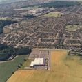
Aerial view Sprowston Green Estate. 2000s

Aerial view Sprowston Green Estate. 2000s

Aerial view Sprowston Green Estate.2000s

Aerial view Sprowston Green Estate. 2000s

Aerial view Sprowston Green Estate. 2000s

Aerial view Sprowston Green Estate. 2000s

Aerial view Sprowston, Barkers Lane. 1990s

Aerial view Sprowston High School. 2000s

Aerial view Lone Barn Road, Corbet Avenue1990s

Parish Council Buildings on Recreation Ground 2000s

Aerial view of home farm and the Blue Boar on Wroxham Road 1950s

UG Key Plastics Factory, Salhouse Road. Aerial View. 2000s.

The Barnard's Factory and Florida Shoe Factory site on Salhouse Road. In the late 1960s

Norwich Sack & Bag Co. factory. Clover Road off School Lane taken in the 1930s This was later taken over by Duffield’s Garage.
Bugdens Supermarket now Tesco`s, Blue Boar Lane. 1980s Aerial View.

Wroxham Road from the air in 1946 showing line of tank traps. Photo taken by the RAF. 1940s

Junction of Recreation Ground Road and Neville Road. The Library car park can just be seen at the bottom left hand corner. 2000s

Looking towards Tescos, Blue Boar Lane aerial shot above Church Lane. The building site in the foreground will become the new doctors surgery on Aslake Close. 2000s

Leveson Road is in the foreground on the right is the junction with Falcoln Road West. Linton Crescent is the road in the centre 2000s

A Boulton & Paul Sidestrand aircraft flying over the works on Salhouse Road Norwich, from the Boulton & Paul magazine 1994. 1930s

Junction of Salhouse Road with Heartsease Lane. The Cavalry Barracks are in the centre of the photograph, including a tented area. In the background is the airfield which had been the cavalry ground. The 1920s.

Front cover of July issue of Sprowston News. The Road running R to l is Cannerby Lane. With the pond area prominent in the centre. 1970s

Blue Boar Public House from the air. Note the old Blue Boar Garage in the background. 1950s

Sprowston Greyhound track close to the Wroxham Road /Sprowston Road roundabout. St. Cuthberts church can be seen on the opposite side of Mousehold Lane. 1970s.


Streets, Roads & Thoroughfares

Allens Avenue in the 1930s

Allens Avenue photo taken in 2015

Allens Lane taken in the 1930s, like many roads in the parish this was not adopted hence its unmade state, building was still in progress on the individual plots hence the mix of styles.

Allens Lane as it was in 2015, taken from approximately the same position as the 1930s photo, the telephone wire post is still prominent even after 70+ years.

Blithemeadow Drive in the early 2000s.

The Sheltered Housing at the end Coughtrey Close in the early 2000s.

Sprowston Road thought to be taken in the 1930s The road going off to the right is Black Horse Opening.

Older style 1930s built bungalows on Corbet Avenue as they appeared in the early 2000s

School Lane in the early 2000s showing the original Sprowston Elementary School now as the Council Offices and Diamond Centre.

The Police Station built on the Wroxham Road in the 1960s?

Bewit Road from Linacre Avenue 2015.

Merlin Avenue being developed in 1965.

Blue Boar Lane. The change in road layout made the Blue Boar PH end blocked off and the new link road became part of a housing development.

New Manor Park Development as seen from Laundry Lane in the springtime 2016.

Sprowston Road approaching Mousehold Lane/School Lane/Wroxham Road Junction in the 1930s. This crossroads would soon be replaced by a roundabout which shows on the 1946 aerial survey.

Salhouse Road from Heartsease airfield view 1953 (Photo Geo Plunkett)

The junction of Sprowston/Silver & Denmark Road looking towards Wroxham Road in 1945. Taken for the Norwich Plan of 1945 this was to be the way to the broads.

Blue Boar Lane in winter 1980?Taken from near the garden centre.

Blue Boar Lane in winter 1980?

Flooded Rosemary Road, delivery by tradesmen was difficult as in the 1950s this road was still unadopted.

Wroxham Road in the early 2000s, these houses were built of local red bricks.

The Development of Trendall Road. 1960s

Rowan Court Sprowston Blithewood Gardens 2000s

Mousehold Lane as it was until its widening in the 1960s

Glenburn Avenue looking towards Wroxham Road from Neville Road. 1930s

Leverson Road in the early 2000s

Church Lane in the 1940s looking from Barkers Lane towards the church, the area to the left is now a community open space.

School Lane in the 1930s.

Wroxham Road in the 1930s.

Sprowston Road looking towards county from outside Harrisons Corn Store in early 1930s

Mousehold Lane / Gurney Road / Heartsease Lane/ Salhouse Road junction. 1950s.

Looking towards Sprowston Road in the 1930s from a point approximately where Moorland Close now is.

How Stonehouse Road looked in the 1970s, complete with post war prefabs built for temporary housing in 1945/46.

Junction, looking towards Mousehold Lane, Wroxham Road on the left. 1930s.

Look towards Wroxham on Sprowston Road in 1945. Pet food and animal feed shop adjacent to Cobb Row. A person with pram is near junc with Wall Road. Note all street furniture painted white for blackout conditions during the recent war.

Junction of Sprowston Road / Silver Road showing tram shed offices as retail premises. Taken early 2000s.

Mousehold Lane looking towards Heartsease Lane Boulton & Paul Hangar on corner. 1930s

Flooded Rosemary Road. 1950s

Flooded Rosemary Road. 1950s

In the winter of 1959 - The Loke off Barkers Lane (now called Millennium Loke) looked like this.

Sprowston Road looking towards Wroxham 2015.

Wroxham Road looking toward Norwich from near Rangoon Close. 2010s

Linacre Avenue looking toward Blue Boar Lane. The Road on the right is Bewit Road.The 1960s

Blue Boar Public House, Wroxham Road, view towards the City in the 1930s.

Wroxham Road looking towards Wroxham in the 1950s.

Wroxham Road looking towards Wroxham in the 1950s.

Resurfacing Sprowston Road in the early 1950s corn store, bakery and garage visible in the background.

Moore Avenue before the Cherry trees were removed in the 1990s to prevent damage to the footpaths.

Cozens Hardy Road from Wroxham Road. Dixon Road nameplate can be seen on the side of the house between the two posts. No. 41 is the 4th. house past the road and was owned by Kingston Fowler.


Buildings
Wroxham Road Police Station built in the 1960s this view was taken in the early 2000s.

The Methodist Church on the corner of Sprowston Road/Shipfields taken in the early 1900s.

Mac Handbags factory on Mousehold Lane in 1953. The factory was originally the works of Grange and Samuel Builders.

The Racecourse Inn, Salhouse Road in the early 2000s. The building had originally been Sprowston Grange before becoming The Washington, The Grange before taking on its present guise.

Florida Shoe Company warehouse on Salhouse Road 2000s

The Vicarage Wroxham Road. 1990s

Sprowston Pavilion Recreation Ground 2000s.

The Lazar House, Sprowston Road. 1970s

Senior Citizens Club on Wroxham Road. In the 2000s, before political correctness it had been built as and called Sprowston Old Folks Welfare Club

The Chapel on Gage Road Sprowston. 2000s

Yaxleys Garage on Wroxham Road in the 1950s. The white gatepost just to the right of the petrol pump is the gateway to the vicarage.

No 1 Glenburn Avenue, on the corner of Albion Drive. Re Thatched in 2009.

Methodist Church, on the corner of Wroxham and Cozens Hardy Road.2000s

Flowerdew’s Garage on Sprowston Road as Sprowston Mill is in the background it easily dates the photo as pre 1932. In the 1960s the premises were demolished being replaced by a BP filling station. This to has since been redeveloped as an Aldi supermarket.

Aldi Store in 2015, where the Sprowston Road Garage later BP Garage / Filling Station had stood opposite Shipfields. On the grassed area on the right had stood the Methodist Chapel.

Gurney Estate surveyed their properties in 1906 this Church Farm Farmhouse – Church Lane as it was then. The property is still extant although now in Church Green and much modernised.

The Old Vicarage 55, Wroxham Road in the early 2000s. The tithe deeds are supposed to be in the custody of the guardians of Queen Ann's Bounty.


